

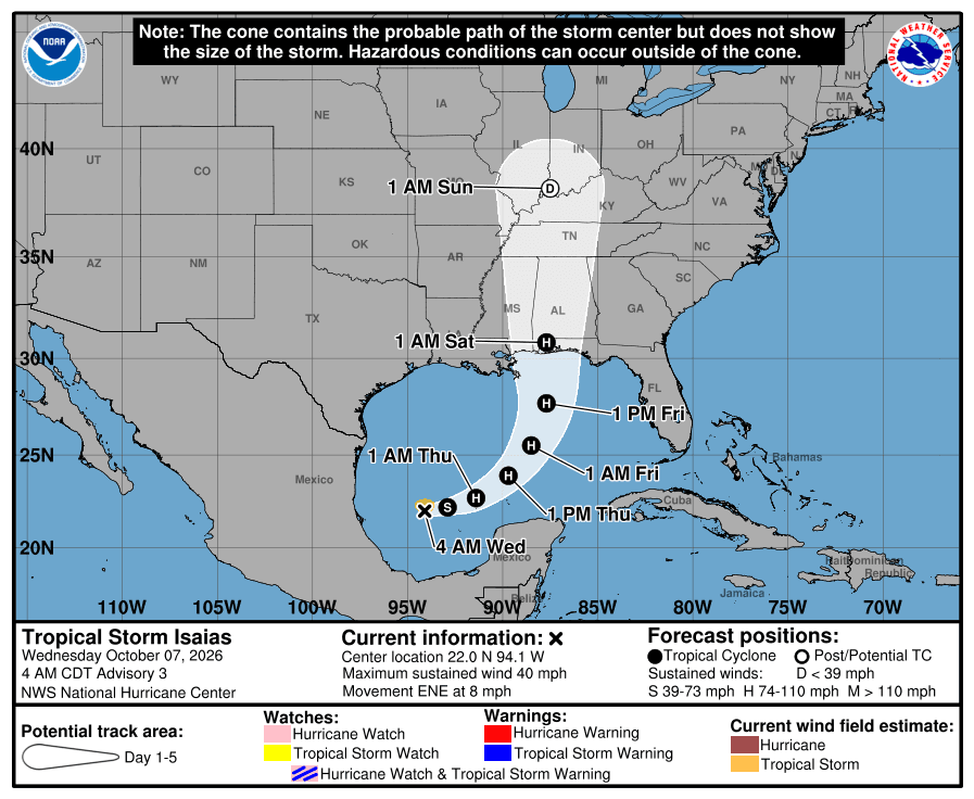
TAMPA — The Gulf system Tampa Bay has been watching since Monday is now Tropical Storm Isaias, and the National Hurricane Center expects it to strengthen quickly into a hurricane before it reaches the northern Gulf Coast late Friday or early Saturday.
The forecast track keeps the center well west of Tampa Bay, aimed at the coast between Louisiana and the Florida Panhandle. Around the bay, the bigger concerns are more rain, rough Gulf waters and dangerous rip currents at area beaches late Thursday into Friday.
Where Isaias is now
In its 5 a.m. ET advisory, the hurricane center said Isaias was about 285 miles west of Progreso, Mexico, with maximum sustained winds near 40 mph. It was moving east-northeast at 8 mph. The depression became a named storm overnight after a buoy north of the center measured tropical-storm-force winds, forecasters wrote in their forecast discussion.
Isaias is expected to pass north of the Yucatan Peninsula on Thursday, then turn northeast and north. Forecasters call for rapid strengthening over very warm Gulf water, with Isaias becoming a hurricane by Thursday and peaking near 110 mph over the central Gulf. That would make it a Category 2 storm. Wind shear should increase before landfall, but the hurricane center said it “is looking more likely that Isaias will be a significant hurricane when it reaches the coast.”
There are no watches or warnings yet. The hurricane center said hurricane and storm surge watches will likely be needed for part of the northern Gulf Coast later Wednesday. Air Force Reserve and NOAA Hurricane Hunters are scheduled to fly into the storm later in the day.
Track confidence is below average. Forecasters noted a wide spread between models, and the latest forecast cone shifted east from the previous one. FOX 13 meteorologist Dave Osterberg projects landfall just west of the Florida Panhandle near Mobile Bay, Alabama, and expects Isaias to become the Atlantic season’s first hurricane, possibly at Category 2 or Category 3 strength.
What it means for Tampa Bay
Tampa Bay is not in the forecast cone, and the hurricane center’s wind speed probabilities do not list Tampa or St. Petersburg. Cedar Key, the closest Gulf Coast city on that list, has a 3% chance of tropical-storm-force winds. The odds climb sharply farther west, to 45% in Panama City and 56% in Pensacola.
Locally, the wet week continues regardless. A stalled front over Central Florida is pulling a deep plume of tropical moisture across the region, and the National Weather Service in Ruskin expects numerous showers and scattered storms for the next several days, with locally heavy rain and minor flooding in urban and low-lying areas. The heaviest totals are most likely near the coast.
As Isaias lifts north on Friday, it will drag that front back north and turn Tampa Bay’s winds southeasterly, setting up another round of widespread showers and storms Friday and again Saturday, according to the weather service. Forecasters also expect building swells and a high risk of rip currents at area beaches late Thursday night and Friday. Small craft conditions on the Gulf are likely to be hazardous through the end of the week.
Drier air is expected to move in early next week, with dew points falling back into the 60s.
State of emergency stops at the Big Bend
Gov. Ron DeSantis signed an executive order Tuesday declaring a state of emergency in 25 counties ahead of the storm. The list runs from Escambia to Columbia and Baker and dips down the Big Bend to Dixie and Gilchrist. No Tampa Bay county is on it.
The state is staging generators, fuel, water, meals, tarps, sandbags and flood barriers in Tallahassee and the Santa Rosa area, the governor’s office said. Anyone with plans to drive to the Panhandle or Alabama coast this weekend should watch the forecast closely. Preparedness checklists are at FloridaDisaster.org.
TBO first reported on the system on Monday, when the hurricane center gave it a 70% chance of development. Read that story.